
Nevada is home to more than 600 ghost towns, which greatly outnumber the state’s current populated communities and towns.
The silver boom created hundreds of mining camps across the Nevada desert between the 1860s and early 1900s. When the ore ran out, people walked away from entire towns in a matter of weeks. What makes Nevada different from other Western states is how well these sites survived. The dry climate preserved wooden buildings, machinery, and artifacts that would have rotted away anywhere else.
Some ghost towns became tourist attractions with gift shops and entry fees. Others remain exactly as miners left them, accessible by dirt roads that require high clearance vehicles and a sense of adventure.
The ten ghost towns below represent the best Nevada has to offer, from fully restored sites with guided tours to remote camps where you might be the only visitor for days.
NORTHERN NEVADA MINING CAMPS
The northern part of Nevada saw some of the richest silver strikes in American history, and the ghost towns here reflect that wealth with substantial brick buildings and complex mining infrastructure that still stands today.
Berlin-Ichthyosaur State Park
Most ghost towns make you choose between history and natural wonders, but Berlin delivers both in a single remote location that only sees a few thousand visitors each year. The mill processed $849,000 in gold and silver between 1897 and 1911, which translates to roughly $27 million in modern value. When the company went bankrupt in 1911, workers abandoned the site mid-shift, leaving tools on benches and supplies in the assay office.
The preservation at Berlin is accidental, not intentional. No historical society stepped in to restore buildings or create museum displays. The structures survived because the location is 23 miles from the nearest paved road, which kept vandals and souvenir hunters away for decades.
The state park designation came in 1957, but not because of the ghost town. Paleontologists discovered North America’s most abundant ichthyosaur fossils in the mountains above Berlin, and the ghost town became an unexpected bonus for visitors making the drive. You can tour the mill, stamp house, mine superintendent’s home, and machine shop on a self-guided walk. The buildings maintain their original interiors with period furniture, mining equipment, and personal items left behind by workers.
What separates Berlin from typical ghost town experiences:
- The Diana Mine shaft remains accessible with proper caving gear and permits
- Original dynamite boxes, ore carts, and assay equipment sit in their working positions
- The fossil shelter houses 40-foot marine reptiles that swam here 225 million years ago
- Camping is allowed within 100 yards of the ghost town buildings
Most ghost towns require you to imagine what life was like, but Berlin shows you the exact moment everyone left.
The park sits at 7,000 feet elevation, which means heavy snow closes access from November through April. Summer temperatures reach 95 degrees, but the buildings provide shade for exploration. The nearest services are in Gabbs, 27 miles west, where you can fuel up and grab supplies before making the drive on graded dirt roads suitable for sedans in dry conditions.
Timing your visit matters more than most people realize. Spring and fall offer the best weather, and you will likely have the entire town to yourself on weekdays. The fossil shelter operates on a guided tour schedule, but the ghost town remains open for self-guided exploration during all park hours.
Berlin represents what Nevada ghost towns looked like before restoration crews and tourism boards got involved. The authenticity comes from neglect, not preservation, and that makes it one of the most honest historical sites in the state.
Unionville
Mark Twain spent three months in Unionville during 1861, and his descriptions in “Roughing It” paint this town as a frontier settlement where prospectors outnumbered buildings. The population peaked at 1,500 residents in 1870 when silver strikes in the surrounding Humboldt Range justified the construction of proper infrastructure. By 1880, the population dropped to 200, and most businesses had shuttered.
Unionville never fully died, which makes it unusual among Nevada ghost towns. Roughly 20 full-time residents still live here, maintaining a handful of original structures while newer homes blend into the historic landscape.
The Old Pioneer Garden Country Inn operates in a restored 1861 building, offering overnight accommodations and meals in what was once the town’s general store. Across the street, the Unionville cemetery holds graves dating back to 1863, with wooden markers and wrought iron fences still intact. The schoolhouse, built in 1870, sits at the south end of town with its bell tower and original desks visible through the windows.
What makes Unionville worth visiting:
- It is one of the few ghost towns where you can sleep in an original building
- The town sits in a canyon with cottonwood trees and a year-round creek
- Several structures remain privately owned but visible from the main road
- Mark Twain’s cabin site is marked, though the original structure is long gone
The semi-occupied status creates a different experience than fully abandoned sites, where you feel like an intruder documenting decay.
Access to Unionville requires 13 miles of dirt road from State Route 400, and the route washes out during spring runoff. High clearance vehicles handle the road easily, but sedans should check conditions with the Pershing County Road Department before attempting the drive. The town has no services, no cell coverage, and no emergency facilities, so preparation matters.
Photography here works best in morning light when the sun hits the canyon walls. The contrast between maintained homes and decaying structures creates visual tension that tells the story better than any single element could alone.
Most visitors spend an hour walking the main street and exploring the cemetery before heading back to paved roads. Overnight guests at the inn get a deeper experience, with access to hiking trails in the Humboldt Range and stories from locals who know which buildings hold the best history. Unionville shows you what happens when a ghost town refuses to die completely, existing in a state between preservation and decay that feels more authentic than either extreme.
CENTRAL NEVADA SILVER RUSH SITES
Central Nevada experienced multiple boom-and-bust cycles, creating ghost towns with different architectural styles and preservation levels depending on when they were abandoned and how quickly people left.
Belmont
Belmont served as the Nye County seat from 1867 to 1905, which means it was built to last, not just to house miners temporarily. The county courthouse, completed in 1876, still stands as a two-story brick structure with original wood floors and a intact tin ceiling. This was not a rough mining camp, it was a legitimate town with civic pride and construction standards that reflected expectations of permanence.
The silver strikes in the Toquima Range justified the infrastructure investment. Mines in the area produced over $15 million in silver between 1865 and 1887, supporting a population that reached 2,000 at peak production. When the ore played out and the county seat moved to Tonopah, Belmont lost its reason to exist in a single decade.
What survived is remarkable for its variety. The Cosmopolitan Saloon maintains its original bar, back mirror, and tin ceiling with bullet holes from a shootout in 1874. The Highbridge Mill, perched on a hillside south of town, processed ore from six different mines and remains structurally sound enough to explore carefully. The Monitor-Belmont Mill, a massive stone structure north of town, shows the scale of operations at peak production.
Belmont’s layout tells you how mining towns were organized:
- The courthouse and commercial buildings occupy the flat center of town
- Residential structures spread up the hillsides in tiers based on wealth
- Mills and industrial sites sit outside the main district near water sources
- The cemetery occupies a windswept ridge with views of the entire valley
This functional separation makes Belmont easier to understand than ghost towns where everything collapsed into a single cluster of ruins.
About six people live in Belmont full-time, maintaining properties and occasionally opening buildings for tours by appointment. The town has no official visitor center, no entry fees, and no restrictions on where you can walk. The courthouse is usually locked, but the caretaker lives nearby and opens it for visitors who show genuine interest.
The dirt roads around Belmont require attention to conditions. State Route 376 provides paved access to within 10 miles of town, then a maintained dirt road handles the final approach. Sedans can make it in dry weather, but mud and snow create impassable conditions that last for days after storms.
Spring and fall offer the best visiting conditions, with wildflowers covering the hillsides in May and golden aspens appearing in October. Summer temperatures regularly exceed 95 degrees with no shade in the main townsite, making midday exploration uncomfortable. Winter brings snow that can close access roads without warning.
Belmont rewards visitors who take time to explore beyond the main street. The residential areas on the hillsides contain dozens of partial structures with stone foundations and collapsed roofs that show construction methods and living conditions. The mills require careful navigation around unstable floors and open shafts, but they offer the best insight into how ore processing actually worked.
Most ghost towns feel frozen in time, but Belmont feels abandoned mid-operation. Tools sit in the mills, furniture remains in houses, and you can trace the daily routes workers took from homes to mines to saloons. The preservation is not perfect, but it is honest, showing both the ambition of the builders and the speed of the collapse when silver prices dropped.
Rhyolite
This is perhaps my favorite ghost town in Nevada.
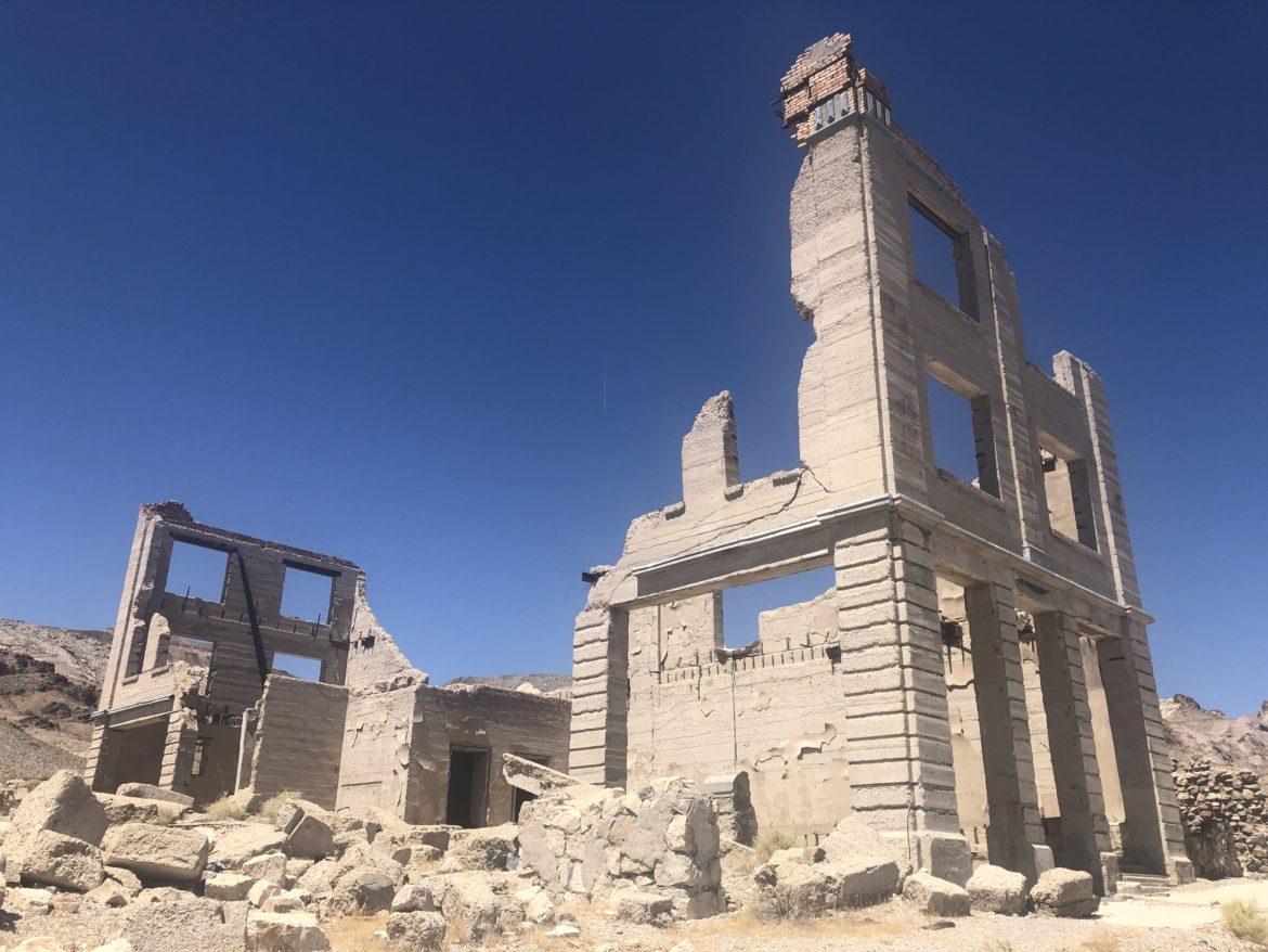
Known as the “Queen of Nevada ghost towns,” Rhyolite went from empty desert to a town of 5,000 people in just two years, then back to empty desert in another five. The boom started in 1904 when prospectors found high-grade gold ore in the Bullfrog Hills near the California border. By 1907, the town had electric lights, a stock exchange, an opera house, and a three-story bank building that looked like it belonged in San Francisco.
The speed of construction created a strange architectural mix. Substantial concrete and stone buildings stood next to tent frames and wooden shacks, reflecting the uncertainty of whether Rhyolite would become a permanent city or another failed mining camp. The answer came quickly when the 1906 San Francisco earthquake triggered a financial panic that dried up mining investment, and the richest ore deposits played out faster than geologists predicted.
By 1910, the population had dropped to 700. By 1920, the post office closed and the last residents left. What remains is a collection of ruins that show both ambition and delusion in equal measure.
The structures still standing at Rhyolite:
- The Cook Bank Building, a three-story concrete structure with vault intact
- The Bottle House, built entirely from 50,000 beer and liquor bottles
- The train depot, a stone building that served the Las Vegas and Tonopah Railroad
- The school, a two-story concrete building with collapsed upper floor
- Remnants of the jail, with barred windows still visible in the walls
These buildings sit among hundreds of concrete foundations that outline where other structures once stood, creating a street grid you can still follow on foot.
The Bottle House became famous not for its architectural significance but for surviving when everything around it crumbled. Tom Kelly built it in 1906 using bottles set in adobe mortar, creating walls that were both insulated and earthquake resistant. The house was restored in 1925 and again in 2005, making it less authentic than the unrestored ruins nearby, but it remains the most photographed structure in town.
Rhyolite’s location four miles from Beatty makes it the most accessible ghost town in Nevada. A paved road runs directly to the site, and you can drive between buildings on maintained dirt roads suitable for any vehicle. The Bureau of Land Management oversees the site with informational signs and a self-guided walking tour, but there are no entry fees, no gates, and no restrictions on exploration hours.
The proximity to Death Valley National Park brings heavy visitation during winter months when temperatures are mild and tourists combine both destinations in a single trip. Summer is brutal, with temperatures exceeding 110 degrees and zero shade anywhere in the townsite. Spring and fall see moderate crowds and comfortable temperatures for exploring the ruins on foot.
Photography at Rhyolite works best in late afternoon when the sun lights up the Bullfrog Hills behind the ruins. The contrast between the concrete structures and the desert landscape creates dramatic images that capture both the ambition and the failure of the town’s founders.
Most visitors spend 30 to 60 minutes walking through the main ruins and reading the interpretive signs, but the surrounding hillsides contain dozens of mine shafts, ore dumps, and smaller ruins that extend the visit for those willing to hike. The townsite covers several square miles, and you can still find artifacts like purple glass, square nails, and ceramic fragments scattered in the desert, though collecting them is prohibited.
Rhyolite shows you what happens when ambition outpaces geology. The town was built for permanence but lasted less than a decade, leaving behind ruins that are somehow both impressive and pathetic at the same time.
EASTERN NEVADA MINING COMMUNITIES
Eastern Nevada’s ghost towns survived longer than most because mining continued sporadically through the mid-1900s, with companies reopening old sites whenever metal prices justified the expense.
Hamilton
The silver boom in White Pine County created Hamilton almost overnight in 1868, and the town became the county seat within a year. At peak population in 1869, roughly 10,000 people lived in Hamilton and the surrounding camps of Treasure City, Shermantown, and Eberhardt. The ore was so rich that miners could chip silver nuggets directly from the walls without processing.
That kind of wealth attracts everyone, including those who have no intention of mining. Hamilton became notorious for violence, with shootings happening weekly and at least one major fire per month burning through sections of the town. The 1873 fire destroyed most of the commercial district, and by that time the easy silver was gone and the population had already started to leave.
What survived the fires and the abandonment are primarily stone and brick structures that were built during the peak prosperity years. The brick courthouse, completed in 1870 at a cost of $60,000, still stands with walls intact though the roof collapsed decades ago. The Wells Fargo building, constructed from local stone, maintains its vault and barred windows. Several residential foundations line the hillsides, marking where the wealthy mine owners built homes with views of their properties.
The structures that remain at Hamilton:
- The Withington Hotel ruins: Three-story stone walls with window openings that frame the valley below.
- The courthouse shell: Brick walls reaching 25 feet high with wooden beams still embedded at floor levels.
- The cemetery: Hundreds of graves on a windswept ridge, many marked only with stones.
- Various stone foundations: Dozens scattered across the townsite showing where businesses and homes once operated.
These ruins sit at 8,400 feet elevation, which means snow covers the site from November through April and temperatures stay cool even in summer.
Access to Hamilton requires 20 miles of dirt road from Highway 50, and the final approach climbs steeply through pinyon pine forest on a road that becomes impassable when wet. High clearance vehicles are recommended, and four-wheel drive is necessary after any significant rain or snow. The remoteness keeps visitation low, and you can easily spend hours at the site without seeing another person.
The surrounding mountains contain dozens of mine shafts and prospect holes that remain open and unguarded. Exploration beyond the main townsite requires caution, proper lighting, and awareness that rescue services are hours away from this location.
Hamilton works best as a destination for experienced ghost town hunters who value authenticity over accessibility. There are no signs, no trails, and no facilities. You navigate by studying the landscape and identifying structures by their relationship to each other. The reward is a completely unfiltered historical site where you experience the abandonment without interpretation or tourist infrastructure getting in the way.
The preservation level at Hamilton is declining noticeably. Stone walls that were intact in 2010 have collapsed sections in 2026, and wooden elements that survived for decades are finally succumbing to weather and gravity. This creates urgency for those who want to see Hamilton before it completes its transition from ghost town to archaeological site.
Gold Point
Most Nevada ghost towns died once and stayed dead, but Gold Point experienced three separate boom periods and is currently in its fourth life as a privately owned attraction. The first boom came in 1880 with gold discoveries that supported a small camp called Hornsilver. The second boom arrived in 1908 when the camp was renamed Gold Point and new mining techniques made lower-grade ore profitable. The third boom happened in the 1930s when gold prices spiked during the Depression.
The current incarnation started in 1979 when Herb Robbins began buying abandoned buildings and moving structures from other ghost towns to Gold Point. This makes Gold Point controversial among purists who argue that relocated buildings destroy historical integrity, but it also means the site has more standing structures than most authentic ghost towns combined.
What you see at Gold Point today includes the original post office, a general store, several residences, a schoolhouse moved from nearby Lida, and multiple mining buildings relocated from camps that have since disappeared completely. Robbins maintained the properties until his death in 2022, and the current owners continue operating the town as a hybrid between a ghost town and an open-air museum.
What Gold Point offers that other ghost towns do not:
- Overnight accommodations in restored miners’ cabins with period furnishings
- A functioning saloon that serves drinks on weekends during the season
- Guided tours that explain both original and relocated structures
- Access to mining equipment displays and artifact collections
The admission fee and commercial operation bother some visitors who prefer completely abandoned sites, but Gold Point provides educational value that pure ruins cannot match.
The town sits 32 miles southwest of Goldfield on maintained dirt roads that sedans can handle in dry conditions. The elevation of 5,600 feet makes summer heat more tolerable than lower desert sites, though temperatures still reach the 90s regularly from June through August.
The authenticity debate around Gold Point misses an important point. Without Robbins’ intervention, most of these buildings would have collapsed or been vandalized decades ago. The relocated structures would have disappeared entirely from their original locations. Gold Point preserves buildings and artifacts that would otherwise be lost, even if their current arrangement is artificial.
Photography at Gold Point is tricky because the maintained condition of the buildings makes them look less authentically abandoned than true ghost towns. The trade-off is that you can photograph interiors with original furnishings, mining equipment in working positions, and architectural details that disappeared from other sites years ago.
Most visitors spend two to three hours exploring the buildings and talking with the owners, who live on site and share stories about the preservation work and the challenges of maintaining a ghost town. Overnight guests get after-hours access to the site and can experience the desert silence that defined these towns after the miners left.
Gold Point represents a specific approach to preservation that prioritizes saving structures over maintaining their original context. Whether that approach is valid depends on whether you value authenticity of location or survival of buildings. Either way, Gold Point shows you what a small Nevada mining camp looked like at peak operation, which is something that unrestored ruins can no longer demonstrate.
SOUTHERN NEVADA MINING OUTPOSTS
Southern Nevada’s ghost towns tend to be smaller and more remote than their northern counterparts, reflecting the limited water supplies and challenging terrain that kept mining operations modest in scale.
Nelson
The mines around Nelson produced gold, silver, copper, and lead from the 1770s through the 1940s, making this one of the longest continuously worked mining districts in Nevada. Spanish missionaries found gold here in 1775, but the isolated location and hostile local tribes prevented sustained mining until American prospectors arrived in the 1850s. The town itself was established in 1905 when the railroad arrived and made shipping ore economically viable.
What makes Nelson unusual is that mining continued long enough for modern safety regulations to take effect. Most of the mines were properly closed and sealed in the 1940s and 1950s, which means fewer open shafts and unstable structures than at older ghost towns where everyone simply walked away.
The townsite today consists of original stone foundations, several wooden structures in various stages of collapse, and the Techatticup Mine stamp mill, which is the most photographed ruin in the area. The mill sits on a hillside with its rusted machinery and wooden frame creating dramatic silhouettes against the desert sky. Nelson’s Trading Post operates in town as a gift shop and rest stop, catering to tourists driving the scenic route through Eldorado Canyon.
The mill and mine structures at Nelson include:
- The stamp mill with exposed ore crushers and wooden framework
- Mine office foundations with partial walls still standing
- Assay office ruins where ore samples were tested for mineral content
- The powder magazine, built into the hillside for explosive storage
- Remnants of workers’ housing scattered along the canyon floor
These structures spread across several acres, requiring walking and some scrambling over uneven terrain to see everything.
Nelson’s proximity to Las Vegas, just 45 miles away, makes it one of the most visited ghost towns in southern Nevada. The paved road through Eldorado Canyon provides easy access, and the scenic drive along the Colorado River attracts tourists who might not specifically seek out ghost towns. This heavy visitation has led to increased vandalism and theft of artifacts, which is why the most interesting structures are now fenced off.
The town has become popular for photography, particularly among influencers who use the ruins as backdrops for fashion shoots and music videos. This created tension between those who want to preserve the site’s historical integrity and those who see it as an aesthetic resource. The property owners allow photography but prohibit climbing on structures or removing artifacts.
Summer in Nelson is brutally hot, with temperatures exceeding 115 degrees in July and August. The canyon location traps heat and blocks wind, making midday visits dangerous without significant water and sun protection. Winter offers comfortable temperatures and better light for photography, but the site sees heavy weekend visitation from November through March.
The authenticity at Nelson is compromised by its accessibility and popularity, but the remaining structures still tell the story of a mining operation that succeeded for nearly two centuries. The mill is particularly valuable for understanding ore processing, as the machinery remains in place even though it has not operated since the 1940s.
Most visitors spend 30 to 60 minutes walking through the main ruins and taking photos before continuing through Eldorado Canyon to the river. Those with more time can hike to additional mine sites in the surrounding hills, though most are fenced and sealed for safety.
Nelson shows you what happens when a ghost town becomes a tourist attraction. The structures survive because of visitation and property owner investment, but the experience feels managed rather than discovered. The trade-off is that Nelson remains accessible to people who cannot handle the remote dirt roads and preparation required for authentic ghost towns like Hamilton or Berlin.

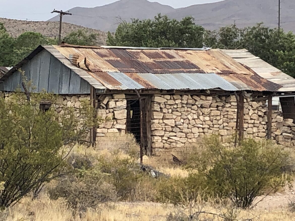
Goodsprings
Mining around Goodsprings started in 1856 but did not reach significant production until the early 1900s when zinc and lead prices spiked due to World War I demand. The town became the largest producer of zinc, lead, and copper in Nevada between 1915 and 1918, supporting a population of 800 and justifying construction of substantial buildings that still stand today.
The most significant structure in Goodsprings is the Pioneer Saloon, which has operated continuously since 1913. This is not a restored building or a museum recreation, it is a functioning bar that serves drinks to locals and tourists while maintaining most of its original architecture and furnishings. The wooden back bar, tin ceiling, and bullet holes in the walls are authentic, and the building appears in dozens of films including portions of “Casino” and “3:10 to Yuma.”
Beyond the saloon, Goodsprings maintains several original structures including the schoolhouse, which was built in 1913 and operated until 1954, and various commercial buildings in different states of preservation. The town never fully died, with a handful of residents staying through the decades after mining ceased. Current population hovers around 230, making Goodsprings more of a living ghost town than a true abandoned site.
What sets Goodsprings apart from typical ghost towns:
- It is still inhabited: Residents maintain properties and operate businesses, creating a hybrid historical site.
- The saloon provides context: You can see how miners actually spent their off hours in an authentic setting.
- Film history adds layers: Movie productions preserved buildings that might otherwise have collapsed.
- Mining remains visible: The surrounding hills show tailings piles, shaft openings, and equipment from various eras.
The occupied status means you need to respect private property and stay on public areas, but it also means the town has services including the saloon restaurant and a small general store.
Access to Goodsprings is easy, with paved roads from Interstate 15 making the 35-mile drive from Las Vegas straightforward for any vehicle. The location at 4,600 feet elevation keeps temperatures slightly cooler than the Las Vegas valley, though summer heat still reaches the upper 90s regularly.
The cemetery on the hillside above town holds particular historical value. Graves date from 1905 through recent years, showing the continuity of the community even as mining ended. Wooden markers, wrought iron fences, and stone monuments create a visual timeline of the town’s evolution from mining camp to rural community.
Photography at Goodsprings requires sensitivity to the fact that people live here. The saloon welcomes photographers inside during business hours, and the exterior structures on the main street are fair game, but residential areas should be avoided unless you have permission. The surrounding mining areas offer unlimited opportunities without privacy concerns.
Most visitors combine Goodsprings with a trip to nearby Red Rock Canyon, making it a convenient addition to a Las Vegas vacation rather than a destination unto itself. This casual visitation pattern means the town sees steady traffic without the overwhelming crowds that affect Nelson or Rhyolite.
The authenticity at Goodsprings comes from continuity rather than abandonment. The buildings survived because people never completely left, and the town evolved gradually from mining center to rural bedroom community. This creates a different type of ghost town experience where you see adaptation and survival rather than dramatic collapse and decay.
WESTERN NEVADA CAMPS
Western Nevada ghost towns sit along the California border where mining camps served smaller operations and support towns for larger mines across the state line.
Como
Como was never a mining town, which makes it unusual among Nevada ghost towns. The settlement started in 1863 as a support community for the lumber industry, harvesting trees from the Pine Nut Mountains to supply mines in Virginia City and Carson City. At peak operation, Como supported two sawmills, a stamp mill for local mineral deposits, and a population of several hundred workers.
The town’s purpose was timber, not treasure. Logs were cut in the mountains, processed at the mills in Como, then hauled by wagon to the Comstock mines 25 miles away. This continued profitably until the early 1900s when the accessible timber was exhausted and Virginia City’s mining boom had ended.
What remains at Como today includes the cemetery with dozens of marked graves, foundation ruins scattered through sagebrush, and partial walls of what was once the town’s main commercial building. The most interesting structure is the stone kiln that was used to produce lime for mortar and plaster, a massive beehive-shaped construction that stands 15 feet tall with walls three feet thick.
Como’s cemetery reveals demographic information that mine-focused ghost towns often hide:
- Family graves showing women and children lived here, not just transient miners
- Dates spanning from 1864 to 1912, documenting the full operational period
- Ethnic diversity including Italian, Irish, Chinese, and Hispanic names
- Occupations listed on markers including logger, millworker, and freighter
This makes Como valuable for understanding the support infrastructure that made Nevada’s mining boom possible.
The townsite sits at 6,200 feet elevation in rolling hills covered with pinyon pine and sagebrush. Access requires eight miles of maintained dirt road from Highway 50, suitable for sedans in dry conditions but impassable when wet. The remoteness keeps visitation extremely low, and you will likely have the entire site to yourself on any given day.
Spring at Como brings wildflowers that carpet the hillsides and make the ruins photogenic. Summer temperatures stay moderate due to the elevation, rarely exceeding 90 degrees. Fall colors appear in October when the aspens in the surrounding canyons turn gold. Winter brings snow that closes the access road frequently from December through March.
The lack of dramatic standing structures means Como appeals primarily to history enthusiasts rather than casual ghost town tourists. The site requires you to read the landscape and imagine what stood where, using foundation outlines and artifact scatter to reconstruct the town mentally. This makes it a thinking person’s ghost town rather than a photo opportunity destination.
The stone kiln is the exception, offering a impressive structure that demonstrates construction techniques and industrial scale. The interior still shows the fire-blackened walls where limestone was heated to 1,800 degrees to produce quicklime. Walking around the kiln and looking up through the top opening gives you a sense of the heat and labor that frontier industry required.
Most visitors spend 45 minutes walking through the cemetery, examining the kiln, and exploring the foundation ruins before continuing along Highway 50. Those with more time can hike into the surrounding forest to find logged areas that are slowly recovering after 150 years, with tree stumps still visible among second-growth forest.
Como shows you the unsexy side of Nevada’s mining history. The glory went to the mines and the wealth went to the mine owners, but the timber workers who kept the mines operating lived and died in places like Como. The ghost town is a reminder that frontier economies required extensive support systems that history usually ignores.
Aurora
Aurora sits on the Nevada-California border, and for the first three years of its existence nobody knew which state it was in. The town was established in 1860 following gold discoveries, and both Nevada Territory and California claimed jurisdiction. Residents voted in both territories’ elections and paid taxes to both governments until a survey in 1863 proved Aurora was in Nevada by about three miles.
That confusion did not slow development. Aurora’s population peaked at nearly 6,000 in 1864, making it larger than Virginia City for a brief period. The town had 17 mills processing ore from dozens of mines, plus all the saloons, brothels, and businesses that supported a major mining camp. Mark Twain worked here as a miner before becoming a reporter, and his letters describe Aurora as a rough town where killings were common and justice was informal.
The decline came quickly when the richest ore played out in the late 1860s. By 1870, the population had dropped below 500. By 1890, Aurora was essentially abandoned. What makes the Aurora story tragic is what happened after everyone left. In the 1960s, a salvage company got permission to bulldoze the entire townsite and recover bricks from the chimneys and foundations. They removed roughly a million bricks and sold them as “authentic Old West building materials,” destroying almost every structure in the process.
What survived the demolition at Aurora:
- The cemetery on a windswept ridge with hundreds of graves and some markers
- Scattered foundation outlines showing the street grid and building locations
- Mine dumps and tailings piles surrounding the townsite
- A few partial brick walls that were too unstable to salvage safely
- Thousands of square nails, purple glass fragments, and ceramic pieces in the surface soil
These remains require significant imagination to appreciate, as Aurora is more archaeological site than ghost town in the traditional sense.
The location is remote, requiring 30 miles of dirt road from Highway 359 near Hawthorne. The final approach crosses several washes that become impassable during and after rainstorms. High clearance vehicles are necessary, and four-wheel drive is recommended. The elevation of 7,600 feet means snow closes access from November through April in most years.
Aurora appeals to ghost town purists who value historical significance over visual drama. The site was one of the most important mining camps in Nevada history, but the destruction of the structures means most visitors see only rubble and foundation outlines. The reward comes from understanding that you are standing where thousands of people lived, worked, and created a substantial town that disappeared almost completely.
The cemetery provides the most tangible connection to Aurora’s past. Wooden markers have long since rotted away, but stone monuments and wrought iron fences mark the graves of those who could afford proper burial. Many graves are unmarked, simple depressions in the soil where wooden markers collapsed decades ago. The location on an exposed ridge means wind is constant, adding to the desolate atmosphere.
Collecting artifacts at Aurora is prohibited, despite the temptation created by thousands of items visible on the surface. The site is on Bureau of Land Management property, and removing historical items is a federal offense. Photography is unlimited, and simply walking the townsite to identify building locations is allowed.
Most visitors spend one to two hours at Aurora, walking the cemetery, identifying major foundation outlines, and hiking to overlook points that show the full scale of the townsite. The surrounding mountains contain dozens of mine openings and prospect holes, most of which are unstable and should not be entered.
Aurora demonstrates that some ghost towns are better remembered than visited. The historical significance is enormous, but the physical remains are minimal, creating a disconnect between what you expect to see and what actually exists. This makes Aurora a destination for serious ghost town hunters rather than casual tourists looking for photogenic ruins.
Nevada’s ghost towns survived better than almost anywhere else in the American West because the desert climate preserved wood and metal that would have rotted away in wetter regions. The ten towns above represent different types of preservation, from fully restored sites like Gold Point to barely visible ruins like Aurora. Each approach tells a different story about Nevada’s mining history and what happens to communities built around a single exhaustible resource.
The best ghost town experiences come from matching your interests to the right site. If you want standing structures and photogenic ruins, start with Rhyolite or Belmont. If you value authenticity over accessibility, make the drive to Hamilton or Berlin. If you want to understand what mining camps actually felt like when occupied, visit Goodsprings or Unionville where elements of the original communities still survive. The common thread connecting all these sites is the reminder that Nevada’s wealth came from the ground, and when the ore ran out, people had no reason to stay.