
The American Southwest isn’t one trip. It’s a half-dozen completely different worlds that happen to sit close enough together that you can drive between them — red rock canyons, slot canyons, hoodoos, ghost towns, and the strange roadside stuff in the stretches between. The trick is stringing them together in a way that makes sense from behind the wheel.
This itinerary does that as the Grand Circle — a classic Southwest loop starting and ending in Las Vegas. You’ll drive north through Zion, arc east through Bryce Canyon and Capitol Reef on Scenic Byway 12, drop south through Kanab and Page, and close the loop back through the Grand Canyon. Every stop is on the route. Nothing backtracks more than it has to.
I live in Las Vegas, so this whole loop is my backyard — I’ve driven these roads multiple times now since I moved to the area over a decade ago. This isn’t a list pulled from other lists. It’s the route I’d actually drive, with the honest version of what each stop is like, including the parts that didn’t go to plan.
The Route at a Glance
The full loop in order, with rough drive times:
- Las Vegas — your launch pad
- Valley of Fire State Park — optional stop on the way out (~45 min from Vegas)
- Zion National Park — ~2.5 hrs from Vegas
- Bryce Canyon & Scenic Byway 12 — ~1.5 hrs from Zion
- Capitol Reef National Park — ~2 hrs from Bryce via Scenic Byway 12
- Highway 89 south to Kanab — backtrack west, then south (~1.5 hrs from Capitol Reef)
- Page, Arizona (Horseshoe Bend, Antelope Canyon, Lake Powell) — ~1 hr from Kanab
- Grand Canyon — North Rim via 89A, or South Rim via Highway 64 (~2.5 hrs from Page)
- Back to Las Vegas — via I-40, Flagstaff, Kingman, and Oatman if you’ve got time for donkeys
This route covers roughly 1,200-1,500 miles depending on Grand Canyon options and side trips.
Before You Go: The Practical Stuff
How long you need. Ten to twelve days does this loop well. You’ll have a couple of longer driving days and stretches where the drive is the activity. Capitol Reef and Bryce both reward an extra night if you can spare it. Treat the version below as the skeleton and add rest wherever your group needs it.
Best time of year. The desert parks punish you in midsummer — the Grand Canyon and Page regularly push past 100°F — while Bryce sits at 9,000 feet and holds snow into late spring. Late April through early June and September through October are the sweet spots: cooler temperatures, better canyon light, thinner crowds. If you’re locked into summer, hike early and be off exposed trails before noon.
Car or camper van. A standard rental car handles the entire route — every road on the loop is paved. A van earns its keep if you want to camp inside the parks, a real advantage at Capitol Reef where lodging is scarce. The tradeoff is fuel cost and tight trailhead parking lots that fill early. For most first-timers, a car plus booked hotels is the lower-stress call.
Where to start. Las Vegas — major airport, cheap flights, competitively priced rental cars, and it sits at the natural entry point for the whole loop.
Leg 1 — Las Vegas & Valley of Fire
Before you drive a single mile toward red rock, give Vegas an afternoon — not for the Strip, but for the country just outside it.
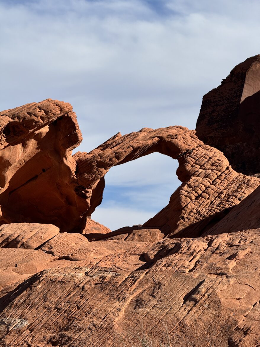
Valley of Fire State Park, about 45 minutes north on the way to Zion, is an optional first stop that’s easy to fold in without adding meaningful drive time. Blazing red Aztec sandstone, easy scenic pullouts, ancient petroglyphs carved into the rock, and a landscape that somehow manages to be surprising even knowing what’s coming for the next ten days. If you’ve only got time for a quick stop, pull off at a few viewpoints and keep moving. If you’ve got a half-day, it earns it. The Wave formation and the White Domes trail are both short and genuinely stunning. It’s one of those places we keep coming back to, partly because it’s close and partly because it never gets old.
One note while you’re there: those petroglyphs are thousands of years old, and Valley of Fire made the news when a visitor carved her own name into a panel. Look, photograph, leave it exactly as you found it. You’ll see rock art at several stops on this loop, and the rule holds every time.
Leg 2 — Zion National Park
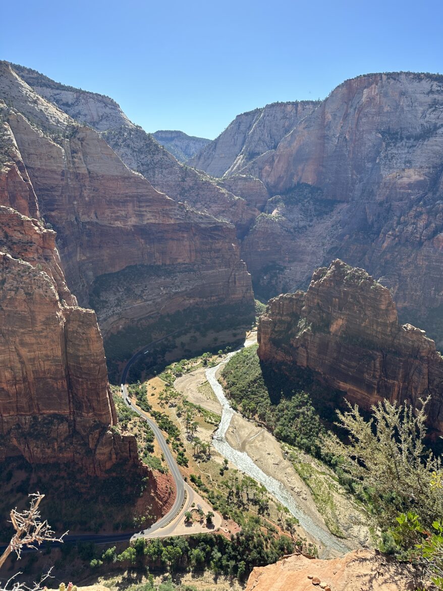
Roughly two and a half hours northeast of Vegas, Zion is the first major park on the loop and for many people the highlight of the whole trip. It’s one of those heavily hyped places that actually earns it — towering canyon walls, the Virgin River cutting through the bottom, and a scale that’s genuinely hard to photograph because you can’t fit it in the frame.
Getting There & The Shuttle
Most of the year you can’t drive your own car up Zion Canyon — you park and take the free shuttle. That sounds like a hassle and turns out to be a relief, because the alternative is gridlock. Get there early: the visitor center lots fill, and the gateway town of Springdale fills behind them. Stop at the visitor center first for current trail and shuttle status before you commit to anything.
The Signature Hikes
Zion’s two famous hikes are famous for opposite reasons.
The Narrows is a hike in the river. You wade up a slot canyon with the walls closing overhead. It’s the one everybody tells you about the moment you mention Zion, and here’s my honest confession: I’ve been to Zion more than once and still haven’t done it. Every trip something bumps it: water levels, timing, the day getting away from us. What the locals consistently tell me: it’s the rare desert hike that stays cool in summer because you’re in the water and out of the sun, and you can turn around whenever you’ve had enough. It’s at the top of my own list for next time, and I’d build a day around it before anything else here.
Angel’s Landing is the opposite. A steep, exposed scramble up a fin of rock with chains bolted in and serious drop-offs on both sides. It now requires a permit through a lottery, specifically because too many people wanted on it. From experience: it really is a lottery, and you may not get the day you want. I’ve applied, missed it, and rebuilt the day around the miss. But last-minute permits open up, and people who live near these parks treat them like gold — I know folks in Vegas who’ll drop everything and drive up the moment a next-day permit lands. If you draw one, take it. And if heights worry you: I’ve touched the Half Dome cables in Yosemite and found Angel’s Landing’s chained section more manageable — there’s solid rock under your feet and something to hold the whole way, not just open air.
Where to Stay & Eat
Springdale, right at the south entrance, exists almost entirely to serve Zion visitors, so food and lodging sit at the park’s doorstep. If it’s booked or pricey, look at Rockville down the road, or Hurricane, Utah, farther out toward Vegas.
Leg 3 — Bryce Canyon & Scenic Byway 12
About an hour and a half from Zion, Bryce feels like nowhere else on the loop. Where Zion is about looking up at canyon walls, Bryce is about looking down into a series of natural amphitheaters packed with hoodoos: thousands of orange rock spires standing together like a frozen crowd, shapes that erosion pulled out of the plateau and left behind.
We finally made it here last week, after years of me hearing about it, and it did the thing the best parks do — you stand at the rim and have to take a second to register that you’re actually inside the postcard.
The Elevation Will Surprise You
Bryce sits high — the far end of the park is up around 9,100 feet — and the temperature does not care what the desert was doing an hour ago. We went on a warm day, drove up to Rainbow Point at the southern end, and got hit with snow flurries. We’d been hiking in the desert that same morning; now there were flurries coming down and old snow on the ground. We stood there going what is happening until another visitor confirmed it. Pack a real layer even in shoulder season, and give yourself a beat to adjust if you’re coming up from low elevation.
Work the Park Backward
The smartest thing we did was drive straight to the far end first. The front of the park near the entrance looked busier, so we blew past it, drove all the way to Rainbow Point, and worked the viewpoints back toward the entrance. It paid off — we had Yovimpa Point (a short walk across the lot, and a completely different view) essentially to ourselves while a crowd built at the other end. If you’re not chasing a specific sunrise slot, consider running the park in reverse.
Parking is wildly uneven. Rainbow and Yovimpa have plenty; smaller viewpoints like Inspiration Point had maybe three or four spaces. From roughly April to October a free shuttle runs out of Bryce Canyon City — park outside the park and let it ferry you between viewpoints. If hitting every viewpoint is the goal, the shuttle is the better play.
Sunrise, Sunset & the Photo-Shoot Circus
The two most popular stops are the first you reach: Sunrise Point and Sunset Point. At the right hour the rock doesn’t so much reflect light as glow, like the light is coming out of the stone itself. Sunset Point is the iconic one, home to the Thor’s Hammer formation.
Be ready for company. The most crowded spot we hit wasn’t even a sunrise viewpoint — it was the Natural Bridge, an arch so photogenic that families had turned it into full photo shoots, outfit changes and all. (One guy was dressed as a leprechaun. I still don’t know who that was for.) At Bryce the question isn’t whether a spot is beautiful — they all are — it’s how many other people figured that out first.
If You Do One Hike
The classic is the Navajo Loop / Queen’s Garden combo, about two and a half miles, and it’s the one that drops you off the rim and down among the hoodoos — the difference between looking at the park and being inside it. A couple we met had done it that morning and described a literal single-file line of people the whole way down. Worth it, but set your expectations.
Why we didn’t do it: we travel with our dog, Chief, and Bryce doesn’t allow dogs on trails. We did the easy Mossy Cave hike instead, and that’s where we ran afoul of the law. We came in from the Escalante side, saw one sign but nothing screaming “Bryce Canyon,” and I brought Chief on the trail without reading the fine print. On the way out, a ranger — in plain clothes, so my first reaction was who are you, exactly — let me know dogs aren’t allowed. Fair enough; it was on the sign. Lesson: read the sign, even when there’s a crowd around it.
All in, we spent about four and a half hours in the park — one hike plus the full scenic drive — and that was a satisfying first-timer’s visit.
Scenic Byway 12: One of the Best Drives in the Country
On the way in from Zion you’ll pass through Red Canyon, where the road runs straight through arches cut into the rock — striking enough that over a million people a year stop here for photos without ever entering Bryce. Don’t blow past it.
Then there’s Scenic Byway 12 itself, the stretch running east through the Escalante country toward Capitol Reef. It’s one of the best scenic drives in the western United States — high, winding, and constantly opening onto new views. It’s widely cited as inspiration for the road Lightning and Sally drive in Cars, including the rock tunnels they pass through, which are real. Pulling up to those tunnels was a kid-on-Christmas moment for me. Amy filled her phone’s storage to capacity on this leg — the first time in her life that’s ever happened, wedding and kids included. That’s the kind of road it is.
One last reason to stick around past dark: Bryce earned international Dark Sky status in 2019, and it has some of the darkest skies in the country. We can vouch for the flip side too — staying outside Escalante during a full moon, the light was so bright I got up convinced a floodlight was glaring through the cabin window. It was the moon. We stood outside and cast actual moon shadows.
Food around Bryce is thin — we ended up driving to the next town over for lunch. The little towns along the route — Tropic, Escalante, and Panguitch (locals say it roughly like “penguin sandwich,” minus the sandwich) — are worth a stop in their own right.
Listen to Unscaled Travel Show – Ep. 160: Bryce Canyon National Park A First Time Visitor’s Guide
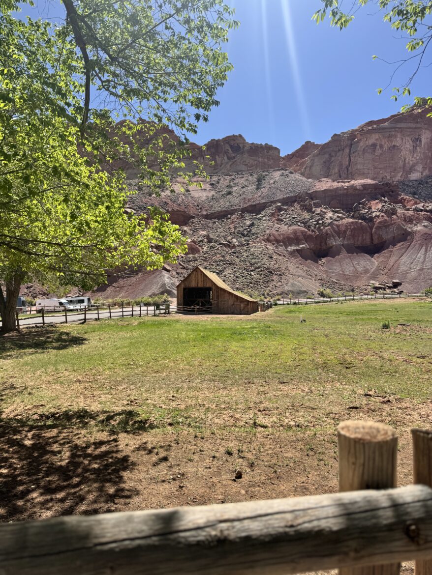
Leg 4 — Capitol Reef National Park
Here’s the park almost nobody plans for, and the one I’d most want to talk you into. Capitol Reef is the most overlooked of Utah’s “Mighty Five” — perpetually overshadowed by Zion and Bryce — and that’s exactly its appeal. It’s quieter, calmer, and strange in a way the others aren’t.
Why Capitol Reef Gets Skipped (And Why You Shouldn’t)
Geography is most of it. Zion and Bryce sit close together on the west side of southern Utah; Arches and Canyonlands sit close together on the east. Capitol Reef is stuck in the middle, requiring extra effort to reach, so people skip it. It also lacks one hang-your-hat hike the way Zion has Angel’s Landing, so it doesn’t get the same buzz.
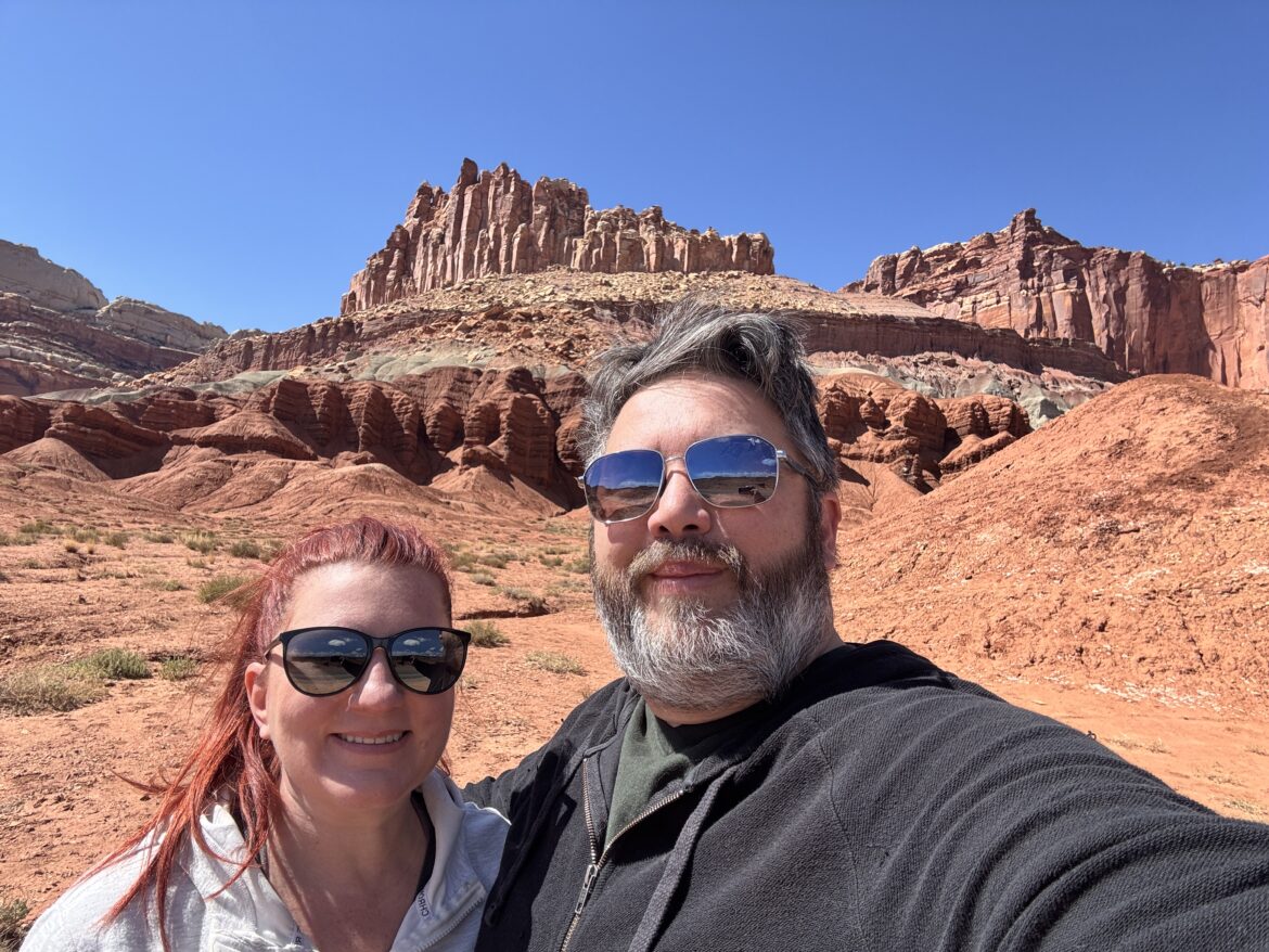
What it protects is the Waterpocket Fold, a nearly hundred-mile wrinkle in the Earth’s crust — one of the largest exposed monoclines in North America. Massive cliffs, white-and-red banded rock formations, and a landscape that genuinely looks like another planet. If Mars has a national park, it probably looks like this.
We only made it here because we were staying between Bryce and Capitol Reef and figured we’d make the extra drive. We’d never have planned a trip around it. Having been, I think everyone should go.
Fruita, the Orchards & the Gifford House Pies
The center of the park is Fruita, an old Mormon settlement, and it’s where Capitol Reef pulls its best trick. You come through stark red rock and then suddenly there are trees, deer in the grass, horses, and historic fruit orchards tucked right up against towering sandstone cliffs — green orchard on one side, Martian rock wall on the other.
In season you can pay a small fee and pick fruit from the orchards. But the real attraction is the Gifford House. Start at the visitor center, spot the sign advertising homemade pies — seasonal, roughly March through October — and follow it. Inside are a couple of small rooms: one full of canned preserves, the next holding a glass-front cupboard stacked with individual-size pies, a case of cinnamon rolls, and an ice cream cart.
There’s always a line, and everyone in it is ordering multiple pies. I went in for two pies and a cinnamon roll and came back out holding bags of the stuff, fully converted. An honest question occurred to me standing in that line: why aren’t more national parks offering pie? While I was buying, Amy and Chief were out front making friends with the Gifford House horses, and we watched a whole herd of deer hanging out in the grass behind the place. It’s that kind of stop.
Hikes & The Scenic Drive
The Capitol Reef Scenic Drive starts right near the Gifford House — pull out of the overflow lot and you’re on it, winding past orchards and rock formations with very little effort. This park is unusually friendly to people who don’t want a brutal hike; you can see an enormous amount from the car and on short walks.
If you want to get out, the trails span a wide range:
- Hickman Natural Bridge — the most popular, for good reason — a moderate walk to a large natural bridge you can stand on.
- Grand Wash — nearly flat, a relaxed walk through towering canyon walls that feel like a movie set.
- Cassidy Arch — moderate but reachable, named after Butch Cassidy, who’s said to have hidden out in this country.
- Capitol Gorge — a deep canyon walk with an optional short hike to the water-pocket “tanks.”
One honest piece of trail advice: actually walk to the arches rather than trusting a roadside sign. I once got out at a viewpoint looking for Cassidy Arch, ran into a woman doing the same thing, and after a while we both agreed the sign was a liar — neither of us could spot the arch from where it pointed. Go to the proper trailhead and hike the trail.
Take the weather seriously here: Capitol Reef gets flash floods. A trail we were on along the Fremont River had washed out and we had to reroute. Check conditions at the visitor center before you head out.
A Note on Food
Inside the park, the Gifford House (seasonal) is essentially the only food. Stock up in the gateway towns of Torrey or Hanksville. Torrey is home to a sandwich shop that will put a frankly heroic quantity of onions on your order if you so much as whisper the word.
Where to Stay
Ofland Escalante sits right on Scenic Byway 12, about 45 minutes from Bryce Canyon, and it’s the best answer to the lodging problem in this stretch. The property offers modern cabins — some with private outdoor showers — and vintage Airstreams, with a pool, hot tub, food truck, and a nightly drive-in movie theater. It’s also Dark Sky certified, which means the same skies that make the moon cast shadows outside Escalante look even better from here with a fire going.
They hosted us in April 2026 and, in my opinion, are the best option in the entire area between Bryce Canyon and Capitol Reef National Park.
Listen to Unscaled Travel Show – Episode 161: Capitol Reef National Park First Time Visitor’s Guide
Leg 5 — Highway 89 & Kanab
From Capitol Reef you backtrack west on Highway 24 to pick up Highway 89, then drop south toward Kanab. It’s not the most glamorous leg, but Highway 89 is the thread that stitches this whole trip together — an old corridor that connected ranching and mining towns long before these parks existed, and one that keeps giving you reasons to slow down.
Kanab: Little Hollywood
Kanab, Utah has earned the nickname “Little Hollywood” — the local museum lists films shot in the area going back to 1924, the kind of westerns that taught the rest of the world what the American West was supposed to look like. It’s a modern little town now, with restaurants and lodging, and a hot-air balloon festival every fall. Use it as an overnight base for Page, which is only an hour east.
Pie, Dinosaurs & the Belly of the Dragon
Just north of Kanab, Highway 89 shows its personality. There’s Moqui Cave with its dinosaur tracks, the Belly of the Dragon — a tunnel you walk through that feels like the inside of some enormous creature — and roadside signs for fossil sites starting the moment you cross into Utah. This whole region turned up so many paleontology discoveries that dinosaur statues and fossil shops just started sprouting along the road.
But the stop people actually circle on the map is the Thunderbird Restaurant, famous — and a little infamous — for its sign advertising “ho-made pie.” (Yes, that’s how it’s written. No, I won’t explain it; just go.) The Thunderbird pies are a legitimate road-trip institution, served fresh daily. Our actual itinerary through here was: walk through the belly of the dragon, then go get homemade pie. That’s Highway 89 in a sentence.
Leg 6 — Page, Arizona: Horseshoe Bend, Antelope Canyon & Lake Powell
About an hour east of Kanab sits Page, Arizona — a town that barely existed before the 1950s, when it was built to house workers constructing the Glen Canyon Dam. Today it’s one of the most photographed corners of the Southwest. Page itself is small — a Walmart, a beloved barbecue joint in Big John’s Texas BBQ, not much else — so book your hotel early; in peak season the rooms run out.
Horseshoe Bend
You’ve seen the photo even if you don’t know the name: the Colorado River carving a near-perfect U into the rock. The honest version of visiting: you pay around $10 to park in the main parking lot, then walk a half-mile to the overlook — uphill on the way out, no shade. We went in summer and badly underestimated it; what looks like a quick five-minute stroll turned into a sweaty twenty-minute slog. Go early or late, bring water. At the overlook there are railings now, but plenty of people climb around them — Amy wouldn’t let me hang my legs over, partly good sense, and partly because if something happened the spouse always gets the blame. The thing that makes the photos work is just that the bend is enormous; you’re standing a long way up.
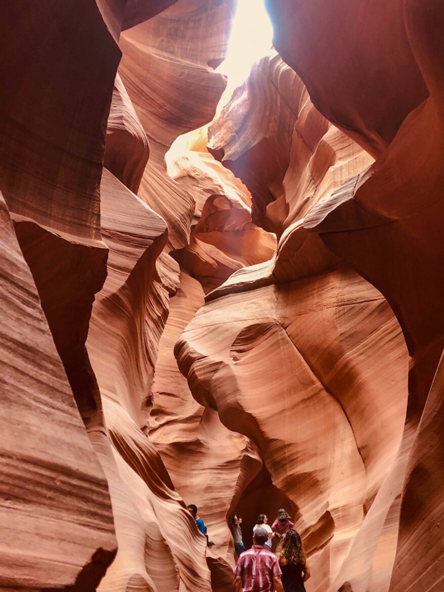
Antelope Canyon & the Slot Canyons
The other marquee stop is Antelope Canyon, and the slot canyons aren’t what most people picture. We drove up expecting mountains with crevices between them, and instead it was flat as far as you could see — because the canyons are in the ground. You climb down a ladder into them. They’re on Navajo land, so you can’t go alone; you book a guided tour (we used Ken’s Tours for the lower Antelope canyon). It can get claustrophobic, especially if a big group bottlenecks ahead of you — we ended up tucked behind a 20-person tour and deliberately hung back for breathing room and clean photos. The guides will tell you as you descend that these canyons flash-flood and you can’t climb out — you walk through to exit. People have died here in floods. It’s safe with a reputable operator watching the weather, but go in knowing what it is. The payoff is real: we still have slot-canyon photos shot on an old iPhone good enough that we saw a nearly identical print for sale in a Vegas art gallery.
Lake Powell, Glen Canyon Dam & The Wave
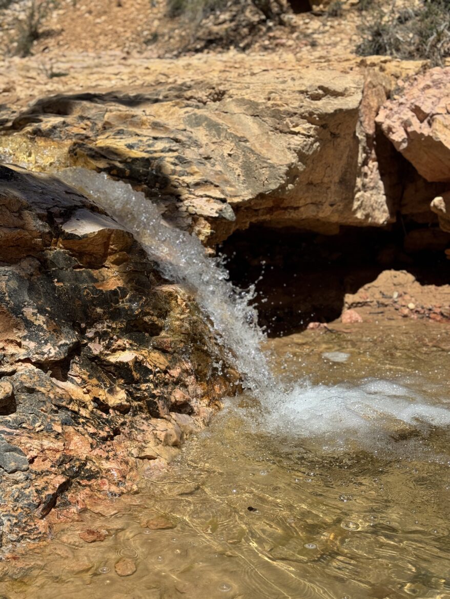
Lake Powell, the reservoir the dam created, is the second-largest in the country by capacity after Lake Mead, and Glen Canyon Dam reads like a smaller cousin of the Hoover Dam — same concept, same look, scaled down. Walk across it, tour the visitor center (which lays out clearly how the Colorado River system connects from here through the Grand Canyon to Lake Mead near Vegas), and photograph it from the Glen Canyon Dam Overlook. An easy nearby hike is the Hanging Garden Trail — flat and short, ending at a rock face where water seeping through sandstone has grown actual hanging vines you can duck behind. Our daughter loved tucking into that alcove.
One more, if you can win the draw: The Wave, that famous swirl of orange-and-red sandstone, runs on a strict daily lottery — apply two days before your date. We’ve tried several times and have never been selected. It’s still on the list. I mention it so you know the lottery is real and competitive, and so you don’t build a day around getting in.
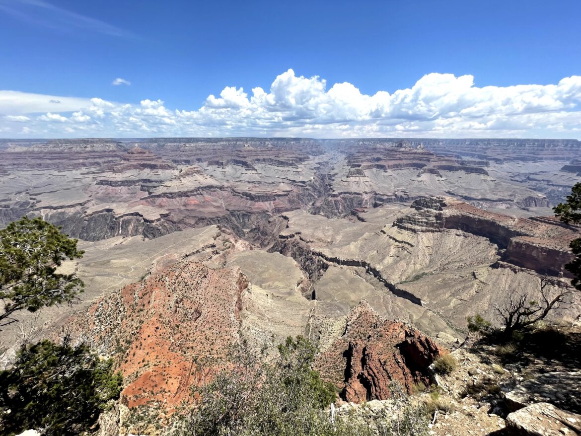
Leg 7 — Grand Canyon National Park
From Page, Highway 89 south connects to the Grand Canyon. You have two options: the North Rim via Highway 89A and 67 (higher, quieter, fewer services, closes in winter), or continue on 89 to Highway 64 west for the South Rim (the main event — most services, most visitors, what most people picture when they picture the Grand Canyon).
Either way, it still doesn’t prepare you. The first time we stood at a South Rim overlook, I told Amy it looked like a painting — from the rim your brain can’t process the scale. Photos don’t do it. Words don’t either. You meet people from all over the world who flew across oceans to look at what Amy calls a very large hole in the ground. It earns the trip.
One bit of history I can’t help sharing: the Grand Canyon was first championed for national park status in 1882 and shot down in Congress repeatedly — mining and ranching interests wanted the land — and didn’t get there until 1919. It was signed in on February 26, which happens to be my birthday, so I’m contractually obligated to mention it.
What to Actually Do
If you’re not a hardcore hiker, the Rim Trail is the move — about five miles of mostly flat, paved path with easy access to the views and no death-march commitment. For something bigger, the classic rim-to-river hikes are Bright Angel (about 10 miles round trip, dropping down to the Colorado River) and South Kaibab (about 7 miles, steeper, with huge panoramic views). The universal warning isn’t a cliché: going down is easy and lures people in; coming back up in the heat is what gets them. Every year there are rescues and tragedies, often from people climbing past guardrails for a photo. The guardrails are not there to ruin your fun.
A word on the Skywalk at the West Rim: we’ve never done it, and we never will, because Amy won’t stand on a glass floor (she wouldn’t do the one at Seattle’s Space Needle either). Their website brags it can hold seventy fully loaded 747s; she remains certain she’d be there the one day they forgot to install a pane. Know your travel companions before you buy that ticket.
Two things still on my list: the Grand Canyon Railway, the historic train that runs in from Williams, Arizona (book early — it sells out), and dinner at the El Tovar Lodge on the rim, where, per a guest we interviewed, elk wander the walkways at night.
Closing the Loop: Back to Las Vegas
From the Grand Canyon, I-40 west takes you back toward Vegas through Flagstaff and Kingman. If you’ve got the time, Oatman, Arizona sits just off old Route 66 between Kingman and the Nevada border — and it’s worth the detour. Oatman is a former gold mining town that boomed in the early 1900s and never quite disappeared, partly because wild burros descended from old mining stock still roam the main street and will walk right up to your car window looking for handouts. Route 66 runs straight through it, and the whole town leans into that history — murals, old storefronts, the kind of place the interstate bypassed and somehow that saved it. It costs nothing, takes an hour, and earns a story. Then it’s back up US-93 to Vegas and the loop is closed.
Ten to twelve days, roughly 1,200 to 1,500 miles, and a route that took you from the tallest canyon walls in Zion to the deepest hole in the earth at the Grand Canyon, with pie, petroglyphs, a slot canyon you didn’t see coming, and a road that inspired a Pixar movie in between. Here’s the thing I keep coming back to after driving these roads as many times as I have: the famous stops deliver — the Grand Canyon really is that big, Zion really is that dramatic — but the trip lives in the stretches between them. The ho-made pie sign north of Kanab. The moon so bright it casts shadows outside Escalante. A rainbow over Monument Valley that’s gone before you can pull over. Out here, the destination is only ever part of the story. Leave room for the rest of it.
A Few More Practical Notes
- Get the America the Beautiful pass. Around $80 for a year, covering a carful of people at every national park on this route. Pays for itself within the first few stops. Military is free; seniors heavily reduced.
- Water and fuel discipline. The stretches of Highway 89 and the road to Page have long gaps between services. Carry more water than you think you need and don’t let the tank get low.
- Respect the railings and the rock art. From Horseshoe Bend to the Grand Canyon, the guardrails exist because people die going around them. The petroglyphs are irreplaceable — look, don’t touch.
- Flash floods are real. In the slot canyons around Page and the narrow washes at Capitol Reef, check conditions before you go in. Water from a storm you can’t see can fill a canyon fast.
- Book ahead where it’s tight. Springdale hotels, Grand Canyon lodges, the Grand Canyon Railway, and Antelope Canyon tours all sell out in peak season.